♫musicjinni

AGU Scientists Tech Talks - Google's Spatial Tools in the Marine Environment - Decision Support

video thumbnail
Google Tech Talks
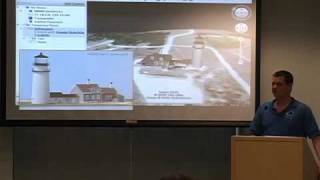
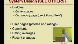
December 16, 2008

ABSTRACT

TITLE: Google's Spatial Tools in the Marine Environment - Decision Support
Presented by: Kurt Schwehr

ABSTRACT: Google Maps and Google Earth have put much of the functionality of Geographic Information Systems in the hands of the end users. Maritime users are just beginning to understand the power of map
mashups that bring together diverse datasets to help mariners and those who manage the waterways to better understand the uses, risks, and impacts of vessel traffic on our nation's waterways. I will present a number of data types ranging from raster images of ocean flow modeling, to vessel traffic over time captured by the marine Automatic Identification System, to real time right whale notices for
vessels approaching Boston Harbor.

How to be a Tummler - Designing for Conversation

When Will We Discover the Extraterrestrials?

The Web That Wasn't

Viewfinder: How to Seamlessly "Flickrize" Google Earth / a collaboration betw...

The Promise of System Configuration

All The Information In The World, The Way You Want

Wuala - a distributed file system

What Every Engineer Needs to Know About Security and...

Quantum Computing Day 1: Introduction to Quantum Computing

The Clean Code Talks - "Global State and Singletons"

What Do Those Images Have In Common?

Tangible Functional Programming

AGU Scientists Tech Talks - Google's Spatial Tools in the Marine Environment - Decision Support

A Possible Future of Software Development

C++ Stylistics

Abstinence does not make the heart grow fonder

No Time to Think

Activity States Framework: A Theoretical Framework for the Analysis of Actual...

If You Had Everything Computationally Where Would You Put it, Financially?

Unleashing Video Search

HOP: A Language for Programming the Web 2.0

Algorithms for Data Management and Migration

Emacs Org-mode - a system for note-taking and project planning

Electricity use and efficiency of servers and data centers: A review of recen...

Copyright regime vs. civil liberties

"The Clean Code Talks -- Unit Testing"

Recommenders Everywhere: The WikiLens Community-Maintained Recommender System

Using Audio Technology to Reduce Global Illiteracy, Poverty

AGU Scientists Tech Talks - Using Google SketchUp with Google Earth for Scientific Applications

IM2GPS: estimating geographic information from a single image

Disclaimer DMCA